
ASIA UPSC
ASIA – Physical features
Asia For UPSC:
Asia comprises of 30% of the world land area & 60% of world population inhabits this continent.
Extent –
-
- Asia includes the eastern portion of the Eurasian supercontinent.
- The border between the two continents runs through the Ural Mountains, the Caucasus Mountains, and the Caspian and Black Seas.
- Asia is bordered by the Arctic, Pacific, and Indian Oceans.
- Asia can be divided into five major physical regions: mountain systems; plateaus; plains, steppes, and deserts; freshwater environments; and saltwater environments

Asia For UPSC MOUNTAINS:

Mountain Systems.
- The Himalaya mountains extend for about 2,500 kilometers (1,550 miles), separating the Indian subcontinent from the rest of Asia.
- The Indian subcontinent, once connected to Africa, collided with the Eurasian continent about 50 million to 55 million years ago, forming the Himalayas. The Indian subcontinent is still crashing northward into Asia, and the Himalayas are growing about 5 centimeters (2 inches) every year.
- The Himalayas cover more than 612,000 square kilometers (236,000 square miles), passing through the northern states of India and making up most of the terrain of Nepal and Bhutan. The Himalayas are so vast that they are composed of three different mountain belts. The northernmost belt, known as the Great Himalayas, has the highest average elevation at 6,096 meters (20,000 feet). The belt contains nine of the highest peaks in the world, which all reach more than 7,925 meters (26,000 feet) tall. This belt includes the highest mountain summit in the world, Mount Everest, which stands at 8,849 meters (29,032 feet).
- The Tien Shan mountain system stretches for about 2,400 kilometers (1,500 miles), straddling the border between Kyrgyzstan and China. The name Tien Shan means “Celestial Mountains” in Chinese. The two highest peaks in the Tien Shan are Victory Peak, which stands at 7,439 meters (24,406 feet), and Khan Tängiri Peak, which stands at 6,995 meters (22,949 feet). Tien Shan also has more than 10,100 square kilometers (3,900 square miles) of glaciers. The largest glacier is Engilchek Glacier, which is about 60 kilometers (37 miles) long.
- The Ural Mountains run for approximately 2,500 kilometers (1,550 miles) in an indirect north-south line from Russia to Kazakhstan. The Ural Mountains are some of the world’s oldest, at 250 million to 300 million years old. Millions of years of erosion have lowered the mountains significantly, and today their average elevation is between 914 and 1,220 meters (3,000 to 4,000 feet). The highest peak is Mount Narodnaya at 1,895 meters (6,217 feet).
Plateaus
Asia is home to many plateaus, areas of relatively level high ground.
The Iranian plateau covers more than 3.6 million square kilometers (1.4 million square miles), encompassing most of Iran, Afghanistan, and Pakistan. The plateau is not uniformly flat, but contains some high mountains and low river basins. The highest mountain peak is Damavand, at 5,610 meters (18,410 feet). The plateau also has two large deserts, the Dasht-e Kavir and Dasht-e Lut.
The Deccan Plateau makes up most of the southern part of India. The plateau’s average elevation is about 600 meters (2,000 feet). It is bordered by three mountain ranges: the Satpura Range in the north, and the Eastern and Western Ghats on either side. The plateau and its main waterways—the Godavari and Krishna rivers—gently slope toward the Eastern Ghats and the Bay of Bengal.
The Tibetan Plateau is usually considered the largest and highest area ever to exist in the history of Earth. Known as the “Rooftop of the World,” the plateau covers an area about half the size of the contiguous United States and averages more than 5,000 meters (16,400 feet) above sea level. The Tibetan Plateau is extremely important to the world’s water cycle because of its tremendous number of glaciers. These glaciers contain the largest volume of ice outside the poles. The ice and snow from these glaciers feed Asia’s largest rivers. Approximately 2 billion people depend on the rivers fed by the plateau’s glaciers.

Asia For UPSC Deserts:
Deserts of Asia
- The Rub’ al Khali desert, considered the world’s largest sand sea, covers an area larger than France across Saudi Arabia, Oman, the United Arab Emirates, and Yemen. It holds roughly half as much sand as Africa’s Sahara desert, even though it is 15 times smaller in size. The desert is known as the Empty Quarter because it is virtually inhospitable to humans except for Bedouin tribes that live on its edges. The Arabian Desert, the largest desert of Asia and the fourth largest desert in the world, is located in Western Asia. The massive desert of about 2,330,000 square km stretches across most parts of the Arabian Peninsula. Despite the extreme conditions, the Arabian Desert hosts some desert-adapted species like the oryx, gazelles, sand cats, lizards, etc. Many species of the desert have become extinct due to overgrazing and hunting. There is very little vegetation in the region. The desert also has areas with treacherous quicksand.
- Gobi Desert located in northern and northwestern China is Asia’s second largest desert and the world’s fifth largest desert.
- Thar Desert – Great Indian Desert or the Thar Desert is a massive desert in the Indian subcontinent’s northwestern section. It forms a natural boundary between India and Pakistan where 85% of the desert area lies within India and the rest in Pakistan.
- Taklamakan Desert is located in the Xinjiang Uyghur Autonomous Region of China
- Dasht-e Kavir, also known as the Great Salt Desert, is located in the central Iranian Plateau region.
- Dasht-e Loot, the 25th biggest desert on Earth, is located in Iran. Here, it occupies parts of the Baluchistan, Kerman, and Sistan provinces of the country. In 2016, the desert was inscribed as a UNESCO World Heritage Site.
ASIA for UPSC – Lakes & rivers
Asia For UPSC:
Lake Baikal, located in southern Russia, is the deepest lake in the world, reaching a depth of 1,620 meters (5,315 feet). The lake contains 20 percent of the world’s unfrozen freshwater, making it the largest reservoir on Earth. It is also the world’s oldest lake, at 25 million years old.
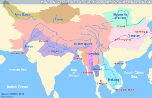
- The Yangtze is the longest river in Asia and the third longest in the world (behind the Amazon of South America and the Nile of Africa). Reaching 6,300 kilometers (3,915 miles) in length, the Yangtze moves east from the glaciers of the Tibetan Plateau to the river’s mouth on the East China Sea. The Yangtze is considered the lifeblood of China.
- It drains one-fifth of the country’s land area, is home to one-third of its population, and contributes greatly to China’s economy.
- The Tigris and Euphrates Rivers begin in the highlands of eastern Turkey and flow through Syria and Iraq, joining in the city of Qurna, Iraq, before emptying into the Persian Gulf. The land between the two rivers, known as Mesopotamia, was the center of the earliest civilizations, including Sumer and the Akkadian Empire. Today, the Tigris-Euphrates river system is under threat from increased agricultural and industrial use. These pressures have caused desertification and increased salts in the soil, severely damaging local watershed habitats.
Microwave digestion is a process by which complex organic and inorganic materials and molecules are heated via microwave energy under sealed, pressure resistant vessels, with acids and other reagents in Microwave digestion system to obtain a clear simple solution appropriate for elemental analysis. Compared with conventional digestion methods, microwave digestion is generally Quick, requires less acid or other reagents and provides better control of temperature and pressure and finally delivers a better solution that can be properly and reliably analysed for its composition. Microwave Digestion by NUTECHANALYTICAL TECHNOLOGIES PRIVATE LIMITED can reach temperatures around 300°C, depending on the model.
Microwave digestion
Microwave digestion is widely used before AAS (Atomic Absorption Spectroscopy), ICP-OES and ICP-MS analysis. It is applied to environmental samples such as soil, water and sludge; food and agricultural products; pharmaceuticals; chemicals; metals and minerals; biological samples; and industrial materials. The technique is particularly useful for determining trace and heavy metals because it produces a homogeneous digest with reduced contamination risk.
Microwave digestion system price
Price: In India, prices are comparably less than in western countries and vary considerably according to capacity, automation, vessel type and safety features. Current listings show systems around ₹6.5 lakh, while higher-end systems can cost approximately ₹9 lakh or more. For example, Amaze Instruments lists a system at ₹6.5 lakh, and Vimal Enterprise lists one at ₹9 lakh. Some listings show much lower prices, but these may represent different configurations or incomplete specifications, so quotations should be obtained before purchase.
Microwave digestion system Manufacturers and suppliers
Major manufacturers/brands include NUTECHANALYTICAL TECHNOLOGIES PRIVATE LIMITED the sole INDIAN Microwave Digestion system manufacturer and supplier along with Anton Paar, CEM and Milestone. Other Indian suppliers/manufacturers include Amaze , Kwality , Vimal Enterprise, National Corporation and Toshvin. NUTECH ANALYTICAL Microwave Digestion also provide Indian and worldwide sales and service support.
hbuuuuuuuuuuuuuuuuuuuuuuuuu
Welcome to WordPress. This is your first post. Edit or delete it, then start writing!