AUSTRALIA OCEANIA PHYSICAL POLITICAL ECONOMY
AUSTRALIA and OCEANIA MINERALS
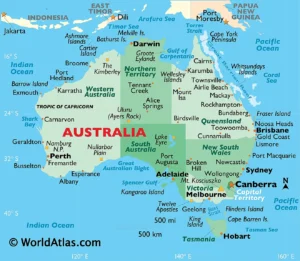
AUSTRALIA AND OCEANIA KEY FACTS - PHYSICAL BOUNDARIES
AUSTRALIA PHYSICAL GEOGRAPHY UPSC:
There are a variety of definitions of Oceania. The most plausible is to refer to the vast regions, island territories and adjacent seas in the Pacific Ocean, east of Maritime Southeast Asia and Australia and west of South America.
- Countries in Oceania - In the vast area of Oceania, there are 14 independent countries and several dependent territories.
- Australasia --The region consisting of Australia, New Zealand, New Guinea, and neighboring islands in the Pacific Ocean is sometimes referred to as Australasia.
- Largest country in Oceania - By far the largest country in Oceania in terms of area is Australia with 7,692,024 km², followed by Papua New Guinea with 462,840 km² and New Zealand with 270,467 km².
- Smallest independent country - The smallest independent country in Oceania is the island nation of Nauru, which covers an area of 21 km² (8 sq mi).

AUSTRALIA PHYSICAL GEOGRAPHY UPSC:
Australia
Australia is the smallest of the seven continents on Earth. Between 1788 and 1868, the British used the continent as a penal colony.
Australia became independent from the United Kingdom in several steps, and it was not until the 3rd of March 1986 that Australia gained full independence from Great Britain.
Area of Australia
Including the adjacent island of Tasmania, Australia covers an area of 7,692,024 km² (2,969,907 sq mi), which corresponds to about 5.6% of Earth's landmass. In comparison, Australia is slightly smaller than the contiguous United States. One country, Australia, occupies the continent.
Map of the Regions in Oceania:
The map shows the various, partly overlapping regions of Oceania: Micronesia, Melanesia, Polynesia, and Australasia, as well as the parallel of latitude 23°26ʹ south, known as the Tropic of Capricorn. Depicted on the map is also the course of the International Date Line (IDL) along the 180th meridian (180° longitude), with diversions to pass around some island groups such as Kiribati.
New Zealand is a geographically isolated island nation in the southern Pacific, situated about 2,000 km (1,250 mi) southeast of Australia's east coast. 4.9 million people live in New Zealand (in 2022) . The country consists of two main islands: the North Island (Te Ika-a-Māui) and the South Island (Te Waipounamu).
| Fiji | 936,000 | Suva | |
| New Caledonia | 294,000 | Nouméa | |
| Papua New Guinea | 9,097,000 | Port Moresby | |
| Solomon Islands | 672,000 | Honiara | |
| Vanuatu | 306,000 | Port-Vila |
| Guam | 171,000 | Hagåtña (Agana) | |
| Kiribati | 126,000 | Tarawa | |
| Marshall Islands | 53,000 | Majuro | |
| Micronesia (Federated States of) | 109,000 | Palikir | |
| Nauru | 11,288 | --- | |
| Northern Mariana Islands | 56,000 | Saipan | |
| Palau | 23,000 | Ngerulmud, Melekeok |
| American Samoa | 56,000 | Pago Pago | |
| Cook Islands | 18,000 | Avarua | |
| Easter Island (Chile) | 7,750 | Hanga Roa | |
| French Polynesia (Tahiti) | 294,000 | Papeete | |
| Hawaii | 1,433,000 | Honolulu | |
| Niue | 2,000 | Alofi | |
| Pitcairn | 50 | Adamstown | |
| Samoa | 203,000 | Apia | |
| Tonga | 113,000 | Nuku'alofa | |
| Tuvalu | 12,000 | Funafuti |
Major Physiographic Features of Oceania
Major physiographic regions of Australia/Oceania include:
The southwestern part of the Pacific Ring of Fire, the Great Barrier Reef, Australia's Outback, the Great Dividing Range in Australia, the North Island Volcanic Plateau and the Southern Alps in New Zealand, the rain forest covered New Guinea Highlands and the coral islands of Micronesia and Polynesia.
AUSTRALIA PHYSICAL GEOGRAPHY UPSC
RIVERS, EARTHQUAKES, DESERTS & LANGUAGES
AUSTRALIA PHYSICAL GEOGRAPHY UPSC:
Major Physiographic Features of Oceania:
Major physiographic regions of Australia/Oceania include:
The southwestern part of the Pacific Ring of Fire, the Great Barrier Reef, Australia's Outback, the Great Dividing Range in Australia, the North Island Volcanic Plateau and the Southern Alps in New Zealand, the rain forest covered New Guinea Highlands and the coral islands of Micronesia and Polynesia.
Great Barrier Reef: World Heritage since 1981:
The Great Barrier Reef is the world's largest coral reef system, composed of over 2,900 individual reefs[ and 900 islands stretching for over 2,300 kilometres over an area of approximately 344,400 square kilometres. The reef is located in the Coral Sea, off the coast of Queensland, Australia, separated from the coast by a channel 100 miles wide in places and over 200 feet deep. The Great Barrier Reef can be seen from outer space and is the world's biggest single structure made by living organisms.
- The entire ecosystem was inscribed as World Heritage in 1981, covering an area of 348,000 square kilometres and extending across a contiguous latitudinal range of 14o (10 0 S to 24 o S). The Great Barrier Reef (hereafter referred to as GBR) includes extensive cross-shelf diversity, stretching from the low water mark along the mainland coast up to 250 kilometres offshore. This wide depth range includes vast shallow inshore areas, mid-shelf and outer reefs, and beyond the continental shelf to oceanic waters over 2,000 metres deep.
- The latitudinal and cross-shelf diversity, combined with diversity through the depths of the water column, encompasses a globally unique array of ecological communities, habitats and species. This diversity of species and habitats, and their interconnectivity, make the GBR one of the richest and most complex natural ecosystems on earth. There are over 1,500 species of fish, about 400 species of coral, 4,000 species of mollusk, and some 240 species of birds, plus a great diversity of sponges, anemones, marine worms, crustaceans, and other species. No other World Heritage property contains such biodiversity. This diversity, especially the endemic species, means the GBR is of enormous scientific and intrinsic importance, and it also contains a significant number of threatened species. At time of inscription, the IUCN evaluation stated "… if only one coral reef site in the world were to be chosen for the World Heritage List, the Great Barrier Reef is the site to be chosen".
Pacific Ring of Fire
The Ring of Fire, also referred to as the Circum-Pacific Belt, is a path along the Pacific Ocean characterized by active volcanoes and frequent earthquakes. The majority of Earth’s volcanoes and earthquakes take place along the Ring of Fire.
Geographical Stretch of Ring of Fire
- The Ring of Fire is stretched to approximately 40,000 kilometers (24,900 miles) tracing boundaries between several tectonic plates including the Pacific, Juan de Fuca, Cocos, Indian-Australian, Nazca, North American, and Philippine Plates.
- The chain runs up along the western coast of South and North America, crosses over the Aleutian Islands in Alaska, runs down the eastern coast of Asia past New Zealand and into the northern coast of Antarctica.
- Bolivia, Chile, Ecuador, Peru, Costa Rica, Guatemala, Mexico, United States, Canada, Russia, Japan, Philippines, Australia, Papua New Guinea, Indonesia, New Zealand, and Antarctica are some of the important places located in the ring of the fire.
Mountains
Highest Point
Puncak Jaya or Carstensz Pyramid in the Papua Province of Indonesia on the island of New Guinea is at 4,884 m (16,024 ft), the highest peak in Oceania.
Mauna Kea on the island of Hawaii is at 4,207.3 m (13,803 ft) above sea level Oceania's second-highest peak. Mauna Kea is also the highest mountain on Earth. Measured from its base on the ocean floor to its summit, it rises over 10,210 m (33,500 ft).
Mount Kosciuszko in New South Wales is the highest mountain in Australia at 2,228 m (7,310 ft).
The Great Dividing Range, also known as the Eastern Highlands, is a 3,500 km long mountain range along the eastern coast of Australia. The highest peak is Mount Kosciuszko at 2,228 m (7,310 ft).
Puncak Jaya (4,884 m) is the highest mountain in the Maoke Mountains (formerly known as the Snow Mountains), part of the New Guinea Highlands (Central Cordillera) on New Guinea. Puncak Jaya, with a prominence of 4,884 m, is also the highest mountain peak of an island on Earth.
Largest Lake:
Theoretically, the largest lake in Oceania/Australia is Lake Eyre (officially Kati Thanda–Lake Eyre) in South Australia, a seasonal lake with a surface area between 8,000 and 9500 km².
Rivers:
- The longest single river in Oceania is the Murrayat 2,508 km. For a long distance, the river forms the border between the Australian states of Victoria and New South Wales.
Darling River is the third-longest river in Australia, measuring 1,472 kilometres from its source in northern New South Wales to its confluence with the Murray River
Deserts
About 35% of the Australian continent is arid and inhospitable. Most of the country's interior, known as the Outback, receives so little rain that it is practically a desert.
There are several named deserts in Australia; the largest by area is the Great Victoria Desert in Western Australia and South Australia. Other deserts are the Great Sandy Desert, the Tanami Desert, the Simpson and the Gibson deserts, and the Strzelecki Desert.
Languages of Oceania
Many different languages were spoken in Oceania before the arrival of the Europeans. The major languages spoken in Oceania today are based on English, some French-based creole, some Japanese, Aboriginal and Torres Strait Islander languages, Melanesian Pidgin, Hawaiian, Polynesian languages, Tahitian, and Maori.